Welcome to LSDTopoTools. This software was developed by members of the Land Surface Dynamics (LSD) research group at the University of Edinburgh.
The software aims to operate:
- As a framework for implementing the latest developments in topographic analysis.
- As a framework for developing new topographic analysis techniques.
- As a framework for numerical modelling of landscapes.
- To improve the speed and performance of topographic analysis versus other tools (e.g., commercial GIS software).
- To enable reproducible topographic analysis in the research context.
This software is constantly used for research and is regularly updated with new routines. Some popular techniques already implemented include:
- Basic topographic analysis
- Channel network extraction from LiDAR data
- Chi analysis
- Calculation of erosion rates from cosmogenic nuclides
- Hilltop flow routing, and hillslope relief metrics
- Topographic extraction of floodplains and terraces
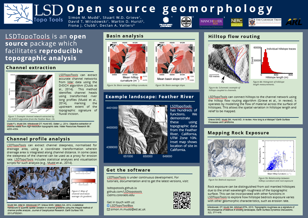
For an overview of some of the features of LSDTopoTools, see this poster, presented at the 2015 BSG Conference:
Download
Start using LSDTopoTools
LSDTopoTools works on any operating system. The best way to start is to read the documentation of our installation instructions and then move on to our first examples. You can install natively on Linux, or you can use either Vagrant and Virtual Box or Docker on any operating system.
We regularly release stable versions of the package in conjunction with the release of papers. These versions are hosted on our Github pages and allow the reproduction of our analysis from our scientific papers.
As the software is constantly evolving and being used to perform cutting edge research our main repository is held on a private github repository. If you are interested in accessing the latest development build please contact the lead developer Simon Mudd (simon.m.mudd at ed.ac.uk).
We also have python scripts to visualise LSDTopoTools output
Current Releases
Many of our software releases have their own doi. See our zenodo page for citable packages
Below is a list of github repositories that store differnt LSDTopoTools components, along with the relevant papers.
If you use our code in a scientific paper please cite the relevant package using the zenodo doi and if appropriate the paper that introduced the algorithms.
If you are interested in contributing code, want to request a feature or find any bugs please post them on the respective github issues page (preferred) or contact us using the details at the bottom of this page.
Docs
Documentation
The full documentation for LSDTopoTools can be found on our main documentation website.
The documentation itself is in a public repoitory so if you wish to fix typos (there are many) or update it in any way just clone, update, and send a github pull request.
If you are just starting, you should read the documentation for our installation instructions and then move on to docuemtation for basic LSDTopoTools analyses.
Our API which documents the code provides lower level guidance to users who wish to contribute to the software package can be found here.
The latest updates to the code can be seen by looking at our twitter feed, which is run by a dangerous AI that is developing a mind of its own.
Publications
Publications
Papers on the algorithms in the software package
Clubb, F.J., S. M. Mudd, D. T. Milodowski, D. A. Valters, L. J. Slater, M.D. Hurst, and A. B. Limaye (2017), Geomorphometric delineation of floodplains and terraces from objectively defined topographic thresholds Earth Surf. Dynam., 5, 369-385, doi:10.5194/esurf-5-369-2017. LINK
Mudd, S. M., M. -A. Harel, M. D. Hurst, S. W. D. Grieve, and S. M. Marrero (2016), The CAIRN method: automated, reproducible calculation of catchment-averaged denudation rates from cosmogenic nuclide concentrations, Earth Surf. Dynam., 4, 655-674, doi:10.5194/esurf-4-655-2016. LINK
Grieve, S. W. D., S. M. Mudd, and M. D. Hurst, (2016), How long is a hillslope? Earth Surf. Process. Land., 41, 1039-1054, doi:10.1002/esp.3884. LINK
Milodowski, D. T., S. M. Mudd, and E. T. A. Mitchard (2015b), Topographic roughness as a signature of the emergence of bedrock in eroding landscapes, Earth Surf. Dynam., 3, 483-499, doi:10.5194/esurf-3-483-2015. LINK
Mudd, S. M., M. Attal, D. T. Milodowski, S. W. D. Grieve, and D. A. Valters (2014), A statistical framework to quantify spatial variation in channel gradients using the integral method of channel profile analysis, J. Geophys. Res. Earth Surf., 119(2), 138-152, doi:10.1002/2013JF002981. LINK
Clubb, F. J., S. M. Mudd, D. T. Milodowski, M. D. Hurst, and L. J. Slater (2014), Objective extraction of channel heads from high-resolution topographic data, Water Resources Research, 50(5), 4283-4304, doi:10.1002/2013WR015167. LINK
Papers that use the software
H.D. Sinclair, S.M. Mudd, E. Dingle, D.E.J. Hobley, R. Robinson, R. Walcott (2017) Squeezing River Catchments Through Tectonics: Shortening and Erosion across the Indus Valley, NW Himalaya, GSA Bulletin, 129(1-2), 203-217, doi:10.1130/B31435.1. LINK
S.M. Mudd (2017), Detection of transience in eroding landscapes. Earth Surf. Process. Landforms, 42(1), 24-41, doi:10.1002/esp.3923. LINK
Clubb, F.J., S.M. Mudd, M. Attal, D.T. Milodowski, S.W.D. Grieve (2016), The relationship between drainage density, erosion rate, and hilltop curvature: implications for sediment transport processes, Journal of Geophysical Research-Earth Surface, 121(10), DOI: 10.1002/2015JF003747. LINK
Harel, M. -A., S. M. Mudd, and M. Attal (2016), Global analysis of the stream power law parameters based on worldwide ^10^Be denudation rates, Geomorphology, 268, 184-196, doi:10.1016/j.geomorph.2016.05.035. LINK
Mudd, S. M. (2016) Detection of transience in eroding landscapes, Earth Surf. Process. Land., doi:10.1002/esp.3923. LINK
Grieve, S. W. D., S. M. Mudd, M. D. Hurst, and D. T. Milodowski (2016), A nondimensional framework for exploring the relief structure of landscapes. Earth Surf. Dynam. 4, 309-325, doi:10.5194/esurf-4-309-2016. LINK
Devrani, R., V. Singh, S. M. Mudd, and H. D. Sinclair (2015), Prediction of flash-flood hazard impact from Himalayan river profiles, Geophys. Res. Lett., 2015GL063784, doi:10.1002/2015GL063784. LINK
Milodowski, D. T., S. M. Mudd, and E. T. A. Mitchard (2015a), Erosion rates as a potential bottom-up control of forest structural characteristics in the Sierra Nevada Mountains, Ecology, 96(1), 31-38, doi:10.1890/14-0649.1.sm. LINK
Hurst, M. D., S. M. Mudd, M. Attal, and G. Hilley (2013a), Hillslopes Record the Growth and Decay of Landscapes, Science, 341(6148), 868-871, doi:10.1126/science.1241791. LINK
Hurst, M. D., S. M. Mudd, K. Yoo, M. Attal, and R. Walcott (2013b), Influence of lithology on hillslope morphology and response to tectonic forcing in the northern Sierra Nevada of California, J. Geophys. Res. Earth Surf., 118(2), 832-851, doi:10.1002/jgrf.20049. LINK
Hurst, M. D., S. M. Mudd, R. Walcott, M. Attal, and K. Yoo (2012), Using hilltop curvature to derive the spatial distribution of erosion rates, J. Geophys. Res. Earth Surf., 117, F02017, doi:10.1029/2011JF002057. LINK
Conference presentations
We also give presentations at conferences and institutions on our research. Here is a list of some highlights, along with copies of posters where available:
Clubb, F.J., S. M. Mudd, D. T. Milodowski, D. A. Valters, L. J. Slater, and M.D. Hurst (2016) Geomorphometric delineation of floodplains and terraces from slope and channel relief thresholds AGU Fall Meeting Poster
Mudd, S. M., M. D. Hurst, S. W. D. Grieve, F. J. Clubb, D. T. Milodowski, and M. Attal (2016), Detecting geomorphic processes and change with high resolution topographic data. EGU General Assembly.
Clubb, F. J., S. M. Mudd, M. Attal, D. T. Milodowski, and S. W. D. Grieve, (2015b). The Relationship between Drainage Density, Erosion Rate, and Hilltop Curvature: Implications for Sediment Transport Processes. AGU Fall Meeting.
Clubb, F. J., S. M. Mudd, M. Attal, D. T. Milodowski, and S. W. D. Grieve, (2015a). The Relationship between Drainage Density, Erosion Rate, and Hilltop Curvature: Implications for Sediment Transport Processes. BSG Annual General Meeting.
Grieve, S. W. D., S. M. Mudd, and M. D. Hurst (2015). Constraining hillslope sediment flux using high resolution topographic data. BSG Annual General Meeting.
Harel, M.-A., S. M. Mudd, and M. Attal (2015), Global scale analysis of the stream power law parameters based on worldwide 10Be denudation rates, EGU General Assembly, Abstract vol. 17, p. 1271.
Clubb, F. J., S. M. Mudd, D. T. Milodowski, M. D. Hurst, and L. J. Slater (2014). Objective extraction of channel heads from high resolution topographic data, EGU General Assembly, Abstract EGU2014-181. PICO Download interactive presentation (PowerPoint)
Grieve, S. W., S. M. Mudd, and T. C. Hales (2014), How long is a hillslope?, AGU Fall Meeting Abstracts, 1, 3588.Poster
Milodowski, D. T., S. M. Mudd, and E. T. Mitchard (2014), How Does Vegetation Impact Hillslope Response to Changing Channel Incision? Insights into Eco-geomorphological Coupling in the Californian Sierra Nevada and Numerical Landscapes, AGU Fall Meeting Abstracts, 1, 3644.
Mudd, S. M., M. Attal, D. T. Milodowski, S. D. W. Grieve, and D. Valters (2014), A statistical technique for identifying channels of different steepness in transient landscapes, EGU General Assembly, Abstract 16, p. 15780.
Valters, D. (2014), Extracting tectonic information using the integral method of river profile analysis: applications along the Wasatch fault, Utah, EGU General Assembly, Abstract 16, p. 16074.
Hurst, M. D., S. M. Mudd, M. Attal, and G. E. Hilley (2013), Hysteresis in hillslope morphology records landscape growth and decay, AGU Fall Meeting Abstracts, 1, 05.
Contact
Get In Touch
Interested? You can follow the project on twitter and contact the developers directly using their contact information.
If you are interested in using the code for research or collaborating with us contact Simon Mudd in the first instance.
Or, if you see us at a conference, come and say hi!


